Stockport South and Underbanks
Tonight's stroll around part of central Stockport takes in a variety of interesting both old and new establishments.
Starting with new, the Wellington was, until 2018, a betting shop and had various functions before that. Very convenient for Grand Central and the rail station, and in this function, replacing the closed Unity a few doors down. Though narrow to the front, the Wellington goes back a long way, so search carefully if joining the stagger here. Internally it is a little like a wedding; something old, something new, probably somethings borrowed, but not sure about the blue!
Up the road, sadly passing the Town Hall Tavern which serves no real ale, plus the actual Town Hall we come to the next location.
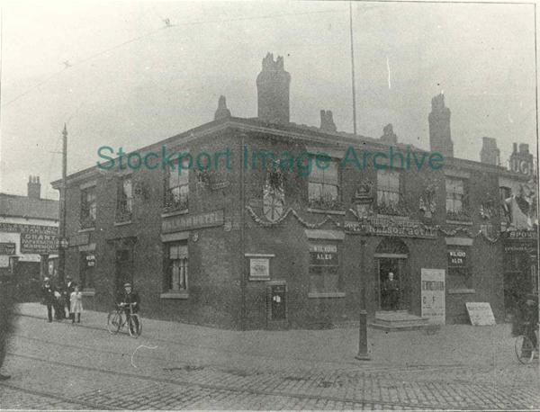
Before entering the Nelson take a moment to cast your eyes over the Edward VII post box which is built in to the wall to the left and can just be made out on the 1908 photo right. The box bears the name W T Allen & Co. of London but was actually cast by James Maude Sherwood Foundry in Mansfield - and we think subcontracting is a modern practice. When installed, post boxes were the internet of their day, offering a service which would allow a message to be sent to Manchester at 9am with a reply before noon. Inside, the Nelson has changed much from its former function as the Nelson Hotel. In term time it can be popular with students from the college next door.
On leaving we trek down the road to what was previously an Indian restaurant and before that...? The Spinning Top is built into the structure which also houses the Garrick Theatre and complements this entertainment ethos. Styling itself as Stockport's premier live music venue means there are performances most days. The walls also host offerings from a variety of artists and occasional other performances are undertaken. Along with the three cask ales, the bar offers a selection of real ciders which are offered at fridge temperatures.
Officially we should now travel along Underbank, but as the Three Shires doesn't sell real ale and the White Lion has still to re-open, it is easier to walk along St Petersgate.
Dropping down the steps and turning left on to Little Underbank we come to the Queen's Head, also known locally as Turners Vaults.
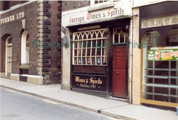
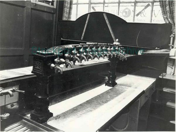 This is because next door (built in to the bridge abutments) used to be a bonded wine warehouse (see photo left). Supposedly customers would meet the salesmen in the vault of the Queen's Head and sample the wines via the ornate dispense on the bar (photo right). This is a Sam Smith's pub so do not use you phone to photograph them as all modern electronic devices are banned (but how they handle card purchases is still a mystery!) Only one beer is on offer, but a multitude of historic features surround you, including a one man only gents — not in current use.
Returning up the steps brings us out opposite the Edgeley Arms, but due to a quirk of compiling these staggers, this isn't on tonight's itinerary!
Across the road we enter Calvert Court, a Wetherspoon's outlet created out of a former furniture shop back in the last century (sounds good, but actually 1999). Going back another century, W & J Calvert, a cabinet-maker, occupied numbers 13 and 15 St Petersgate and Sarah Calvert occupied number 17 as a beer retailer. Calvert Court is even more like a Tardis than the Wellington, going back maybe four or five times its frontage. If intending using the toilets, located at the back, set out early as the walk takes a minute or two!
Finally we move a few doors down to another new kid on (the corner of) the block, the Petersgate Tap. Opened in 2016 in another former betting shop (I'm seeing a trend here!) they started out on a high and have soared higher. Gaining numerous Pub of the Month and Year for both its beer and cider there will be something for everyone. Downstairs it has a modern continental feel with booths and wooden tabling. There are six cask ales along with four continental keg offerings plus an extensive cider menu. Beware - the Petersgate Tap has a penchant for stronger beers, so you can often be faced with several beers of 6% ABV and above - check before you over indulge.
Below, clicking on Map will call up a Google travel map with that location automatically set as the destination. Insert your current location (post code?) as the start and choose a travel mode (public, car, cycle or foot) and discover your travel options.
p>Following THIS LINK will take you to the Transport for Greater Manchester website for current travel information.
Stockport South and Underbanks |
||||
Timing |
Pub Name |
Address |
Bus & Rail |
Notes |
7.30pm Start point: |
The Wellington |
59-61 Wellington Road South |
Map |
|
Then: |
Town Hall Tavern |
95 Wellington Road South |
Map |
No real ale |
Nelson Tavern |
98 Wellington Road South |
Map |
||
Spinning Top |
20 Wellington Road South |
Map |
||
Three Shires (Wine Bar) |
30-32 Great Underbank |
Map |
No real ale |
|
White Lion |
20 Great Underbank |
Map |
Due to open soon |
|
8.30pm Mid point: |
Queens Head |
12 Little Underbank |
Map |
|
Then: |
Calverts Court |
13 St Petersgate |
Map |
|
Se7en |
25 St Petersgate, Stockport |
Map |
No real ale |
|
Finishing at: |
Petersgate Tap |
19a St Petersgate |
Map |
|
View Stockport South & Underbanks stagger in another window.
Updated April 2023
Images on this page are thumbnails from various sources and no right is claimed. If you own copyright and wish either removal or acknowledgement please advise me and I'll promptly follow your wishes.