Burnage Stagger - New route
This is a new route consisting of the first part of the older, pre 2020, Burnage and Heaton Mersey Stagger, then diverts to the centre of Burnage propper.
The name Burnage is conjectured to have stemmed from "Brown Hedge", due to the old brown stone walls (often referred to as "hedges") which were common there in medieval times.

Construction of Kingsway began in 1928 and (like Princess Road) was laid out as a dual carriageway with a segregated tram track along the central reservation (see City Engineer's photo left). So the idea of a tram route to Parrswood (as the terminus in East Didsbury was then referred to) is nothing new. A large housing estate was also built by Manchester City Council along the Kingsway route, mostly characterised by brick semi-detached houses laid out in avenues and octagons. This is the part of Burnage we will be traversing.

Our stagger this evening starts on Burnage Lane at the Farmers Arms. Formally a Hydes house, but now under the control of Lawrence Hennigan of Levenshulme renown. It is a smart, two room, place with Oasis Lounge to the right, and the regular Lounge to the left. A feature of one corner is a series of images and articles about Burnage rock band, Oasis and the lounge sports a stage for entertainment at the weekend.
As we make our way towards our next destination (made easier if we cunningly catch a 197 bus almost door to door) take note of the buildings along Burnage Lane in the vicinity of the Farmers Arms. Here can be seen some surviving original weavers' cottages. Another blast from the past we are unable to see is Mauldeth Hall which is described as being in Green End, and was the dwelling of the Bishop of Manchester for more than 20 years. Just after the Burnage Lane/Erewood Lane roundabout glance to the right at the new housing estate (can I describe around a dozen houses as an estate?) which was the location of the Green End pub. Another point of interest after passing the roundabout is the numbering of the houses on Mauldeth Road. For the first few on the left the numbers are odd and counting down to 313. The next house on the left (beyond the golf course) is back to 1 and again increasing! The explanation is you have crossed the boundary into Stockport from Manchester [incidentally the rest of Mauldeth Road Manchester is located 1 mile away with the Victoria pub on its corner].
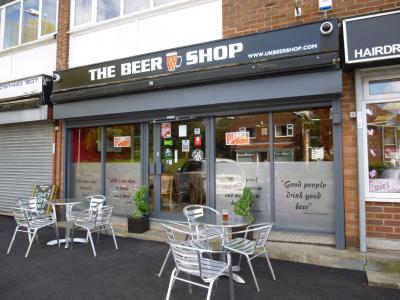
However you travel, our next destination is the Beer Shop that began life in 2011 in a former butchers premises. I'm not sure whether to describe it as an off licence/bottle shop with drinking on the premises or a micro bar with bottles. The owners say it aims to be both a shop, a sample room, and a bar [Grammar Police: can you use 'both' and then give three alternatives?]. An open stillage has up to six beers on sale served by both gravity and handpump. Interestingly, the draught beer list is maintained in real-time on the pub's website. If in a hurry, beer can be taken away in 3, 5, 10 and 20 litre bag-in-box containers [though I advise a 20 litre box is a little awkward to carry around for the rest of the evening]. Should the weather be good(!), tables and chairs are positioned outside. If you are hungry, freshly-baked, home-made pizzas (for consumption on or off the premises) can be obtained from 5 till 9pm on Friday and Saturday.
Another walk is now encountered, but at least it is downhill on Kingsleigh Road then right on Barcicroft Road. As we turn left on Burnage Lane take note of the building opposit standing back from the road, this is the former Albion. Once owned by Hydes, this large corner house had a lounge and vault plus an upstairs meeting room. The lounge was pleasantly furnished and, like most pubs in days past, it was opened out over the years. It had a comfy, lived-in appearance complemented by friendly and chatty service. Laterly promoting itself as a daytime cafe as well as a pub. A long time keg pub, but as of early 2017, Hydes cask beers were returned to the bar. Now all is lost after being sold off.
After a short walk {Hurray!} our next pub will be reached. For those wishing to indulge in the full Oasis tour experience, however, should take a detour left along Cranwell Drive to number 5. This is the location of the brothers Gallagher house and where the photo on the iconic cover of their album was taken.

Back on Burnage Lane keep a look-out for a large, white-painted, house stood back from the road on the right, this is the Sun in September. In keeping with the unusual marketing ethos of the owning brewery, there is little to announce it is a pub (there is a sign board but it is obscured by the mature foliage) and nothing to let you know it belongs to Sam Smiths! Originally built in the 19th century for the local bigwig's daughter as her marital home after coming back from her honeymoon in Switzerland, hence the alpine influences in its architecture. At one time the pub was perversely given an Indian Raj theme but following a more recent refurbishment much of the original house is now open to be seen. With the mansion came impressive grounds where mature trees and well-tended lawns grace the front. WARNING: Should you decide to sit outside, drinks must be served in polycarbonate 'glasses' just in case you develop hooligan tendency and decide to throw them the 25 metres on to Burnage Lane!

On leaving the Sun In September, turn right and right again at the traffic lights on to Lane End Road. Cross Kingsway and continue along Fog Lane. After passing under the railway bridge and station, keep a lookout on your left for Reasons To Be Cheerful which can easily be missed. This converted shop, though narrow at the front, goes back a good distance, with the bar to the front and additional seating to the rear. This area of Burnage had hitherto been very under-pubbed till Reasons To Be Cheerful opened in 2017. Its stated role is to sell locally and independently made real ales and craft beer to sit in or take away. The bar now takes CARD payments only, it no longer accepts cash so you will require some form of contactless payment (or a very good friend who will sub you) if you wish to drink here.
Photo left shows shops in 1960 with Reason To Be Chearful to right of shop named Ashcroft. Click image to see larger version.

On leaving, turn left and at the traffic lights turn left again. Now if, due to skilful timing, a 172 bus is due, hop on for 2 or 3 stops. If not there is another walk along Parrs Wood Road where, after around 10 minute the Parrs Wood hoves into view. In days gone by it was an esteemed Boddingtons house, but after the takeover and break-up of that company (including at one time being the head office of Boddington Pub Co) it entered a long decline into mediocrity.

Travel
Below, clicking on Map will call up a Google travel map with that location automatically set as the destination. Insert your current location (post code?) as the start and choose a travel mode (public, car, cycle or foot) and discover your travel options.
Following THIS LINK will take you to the Transport for Greater Manchester website for current travel information.
Burnage Stagger |
||||
Timing |
Pub Name |
Address |
Bus |
Notes |
7.30pmStart point: |
Farmers Arms |
254 Burnage LaneM19 1EN |
Map |
|
Then |
Victoria Inn |
196 Burnage LaneM19 1FL |
Map |
No real ale |
8.30pm Mid-point: |
Beer Shop |
13 Kingsleigh RoadSK4 3QF |
Map |
|
Then |
Albion |
576 Burnage LaneM19 1NA |
Map |
CLOSED |
Sun in September |
588 Burnage LaneM19 1NA |
Map |
Reasons To Be Cheerful |
228 Fog LaneM20 6EL |
Map |
||
Finishing at: |
Parrswood Hotel |
356 Parrs Wood RoadM20 6JD |
Map |
View Burnage and Heaton Mersey stagger in a separate window.